


Fern Twp. Voting District, Hubbard County, Minnesota
About
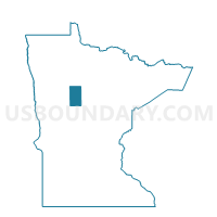
Outline

Summary
| Unique Area Identifier | 602544 |
| Name | Fern Twp. Voting District |
| County | Hubbard County |
| State | Minnesota |
| Area (square miles) | 36.15 |
| Land Area (square miles) | 35.42 |
| Water Area (square miles) | 0.73 |
| % of Land Area | 97.99 |
| % of Water Area | 2.01 |
| Latitude of the Internal Point | 47.35818130 |
| Longtitude of the Internal Point | -95.10887640 |
Maps


Graphs
Select a template below for downloading or customizing gragh for Fern Twp. Voting District, Hubbard County, Minnesota


Neighbors
Neighoring Voting District (by Name) Neighboring Voting District on the Map
- Bear Creek Twp. Voting District, Clearwater County, MN
- Grant Valley Twp. Voting District, Beltrami County, MN
- Itasca Twp. Voting District, Clearwater County, MN
- Jones Twp. Voting District, Beltrami County, MN
- Lake Hattie Twp. Voting District, Hubbard County, MN
- Moose Creek Twp. Voting District, Clearwater County, MN
- Rockwood Twp. Voting District, Hubbard County, MN
Top 10 Neighboring County Subdivision (by Population) Neighboring County Subdivision on the Map
- Grant Valley township, Beltrami County, MN (2,029)
- Rockwood township, Hubbard County, MN (430)
- Jones township, Beltrami County, MN (277)
- Fern township, Hubbard County, MN (270)
- Moose Creek township, Clearwater County, MN (230)
- Lake Hattie township, Hubbard County, MN (202)
- Itasca township, Clearwater County, MN (132)
- Bear Creek township, Clearwater County, MN (111)
Top 10 Neighboring Unified School District (by Population) Neighboring Unified School District on the Map
Top 10 Neighboring State Legislative District Lower Chamber (by Population) Neighboring State Legislative District Lower Chamber on the Map
Top 10 Neighboring State Legislative District Upper Chamber (by Population) Neighboring State Legislative District Upper Chamber on the Map
Top 10 Neighboring 111th Congressional District (by Population) Neighboring 111th Congressional District on the Map
Top 10 Neighboring Census Tract (by Population) Neighboring Census Tract on the Map
- Census Tract 4501, Beltrami County, MN (6,246)
- Census Tract 701, Hubbard County, MN (4,711)
- Census Tract 2, Clearwater County, MN (2,824)